Satellites for development, what is in it for you?
In the past few years there have been a growing array of development projects using satellite images. Some recent examples from our blogs are poverty measurement in Guatemala, overview of the ESA satellites partnership with the Bank, monitoring oil flaring, water resources in India, measuring economic output, measuring agricultural yields, agricultural financial resilience in Ethiopia, Planet labs commit 60 million $ worth of images for development.
At the same time, the satellite industry is undergoing a fundamental transformation with new nanosatellites, new services to buy them, new tools promising to do very complex analysis. IFC investing in Planet Labs, massive image purchases to help open maps, China launches first commercial high-resolution imaging satellite, worldwide monitoring of deforestation, to name a few.
However, despite the growing potential, satellite assets remain niche in development. Development projects are naturally oriented to reduce risks, and the reality is that there is a lack of pragmatism when introducing how satellites can be valuable tools for non GIS experts.
How can I get satellite images? How can they help my project? What new projects are available? What resolution do I need? How much does a satellite image cost for my area? How long does it take? How is this different from Google Maps? Who can help me process the data? These are just some of the very valid questions our team got as we interviewed development colleagues. There is a huge, gap between GIS experts and the general development community. This gap is growing because the inertial spread of satellite examples are quickly superseded with fundamental changes in resources, tools or prices.
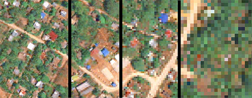
A location in Palawan, Philippines under different resolutions, from left to right 5m, 2.5m, 1.5, 0.5m per pixel, each case suitable for different types of projects.
Today, three of our colleagues are participating at the “Satsummit” a conference designed around the use of satellites in development. Alanna Simpson and Keiko Sato from the Global Facility for Disaster Reduction and Recovery (GFDRR), and myself from Innovation Labs at the Leadership, Learning and Innovation unit. At this conference, we are launching a “Satellite State of Play”. An interactive online one-pager which aims to offer a pragmatic overview to development professionals interested, but not experts yet, on the satellite industry.
Beyond a comprehensive review, this public good is an exploratory dive into the main space of a rapidly moving landscape. That’s precisely the reason we are working to widen the release as soon as possible with a Creative Commons Zero and MIT usage license, hosted on a public and open repository. This will allow anyone to suggest edits, as well as adopt and adapt the content.
Check out the website, and stay tuned for the update with the repository code and license to send your feedback and edit suggestions.