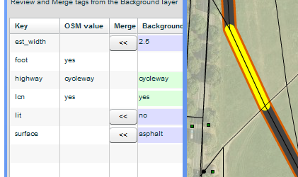
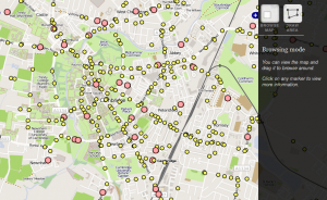
As part of ongoing efforts for the England Cycling Data project, we’ve been keen to get visualisations done, to show the extent of the data and to show where merging needs to be done. Shaun from ITOworld – who are experts …

Visualisations for the England Cycling Data project Read more »

The England Cycling Data project aims to incorporate open data on cycling infrastructure released by the UK’s Department for Transport into OpenStreetMap. We’ve started taking account of a greater range of information about cycle routes in OpenStreetMap (the project from …

England Cycling Data project Read more »

We’re pleased to announce a series of upgrades to the routing that have been rolled out in the last few months. We’ve extended the range of OpenStreetMap tags that the CycleStreets routing engine uses to find cycle routes. This has …

Taking CycleStreets cycle routing another step further: surface quality, barriers, traffic calming, lighting Read more »

If you’re in Cambridge on Thursday, come and hear about CycleStreets behind the scenes, organised by BCS East Anglia! Location: Red Gate Software, 12 Cambridge Business Park, CB4 0WZ  [Cycle there – directions] Date and time: 6:30pm – 8pm, Thursday, 26th April, 2012 The event …

Talk in Cambridge: “Using Open Data and Crowdsourcing to develop CycleStreets” Read more »

We’re pleased to launch today a new resource for the cycling community: a browsable, searchable collision map with complete details of every reported road collision involving cyclists in the UK since 2005. This will also be integrated into our new …

UK Collision Map – a new resource for the cycle campaigning community Read more »

Publishing data is a start, and publishing it in a common standard that others can understand and re-use is the next step; but wouldn’t it be even more useful if you could see correlations between seemingly unrelated sets of data? …

‘Linked data’: making connections between unrelated datasets Read more »